WUI
Fire Prevention in the Wildland Urban Interface (WUI)
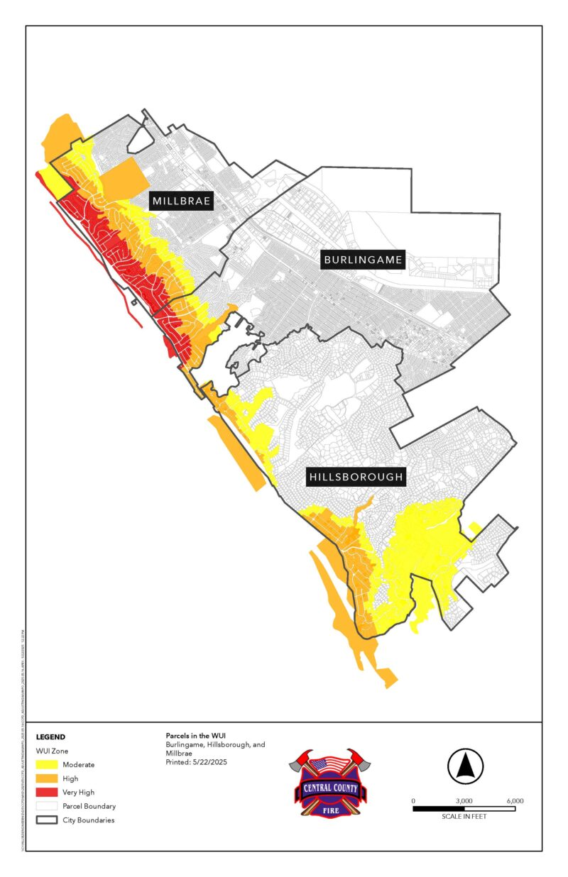
How do I know if I live in a High-Risk Fire Area?
If you live within Central County Fire Department jurisdiction, the adoption of the new Local Responsibility Area (LRA) maps from the State Fire Marshal's Office in 2025 have identified hazard severity zones within the cities of Burlingame, Millbrae, and the Town of Hillsborough.
- For a comprehensive overview from the California
State Fire Marshal's Office, click here.
- For an interactive map, click here.
Applying fire-safe concepts to your landscape is one of the most critical ways to help your home survive a wildfire. As conditions turn dry and windy, vegetation such as dry grasses, trees, and other vegetation surrounding your home can be a dangerous fuel source. Maintaining an area, which we call defensible space (an area of reduced fuel) between your home and potential fuel sources, such as vegetation, minimizes the risk of home ignition.
When your home and landscape are appropriately maintained to fire-safe standards, the threat to your home during a wildfire is reduced. Your home may be the most valuable investment you ever make. If you live in a high-risk fire hazard area, protect against the chance of losing that investment by implementing our fire-safe recommendations.
WUI is the transition between wildland (unoccupied land) and human development. Communities are at a greater risk for wildfire and must take preventative action to eliminate hazards and reduce risks. The following pages contain best-practice actions all residents can take to reduce the risk of wildfire to their homes and our community. It will also help homeowners understand and implement the requirements for homes and properties within the designated WUI area. The Central County Fire Department is committed to working with residents to ensure our communities are properly prepared and protected against wildfires.
NEW FIRE HAZARD ZONES FOR LOCAL RESPONSIBILITY AREAS (LRA)
In 2021, Senate Bill 63 (SB63) expanded the responsibilities of the State Fire Marshal, requiring the identification of moderate, high, and very high hazard severity zones within the LRA. The new maps are based on updated statewide criteria that consider vegetation, terrain, weather, and fire-related conditions. Burlingame, Millbrae, and the town of Hillsborough have all received new fire hazard designations from the State Fire Marshal’s office. With the new designated hazard zones are new requirements for defensible space, home hardening, and natural hazard real estate disclosures for homeowners.
Fire Hazard Severity Zone Maps evaluate “hazard”, not “risk”. Hazard is based on the physical conditions that create a likelihood that an area will burn over a 30–50-year period without considering modifications such as fuel reduction efforts. “Risk” is the potential damage a fire can do to the area under existing conditions, including any modification such as defensible space, landscaping, and home hardening construction methods. The new requirements within the hazard zones are designed to decrease risk and better prepare communities for the threat of wildland fire.
Vegetation Maintenance Self-Survey Checklist
- Mow annual weeds and grasses from the property up to the road and along driveways.
- Remove dead vegetation, trees, shrubs, and bushes.
- Keep roofs and rain gutters free of leaves and debris.
- Trim tree limbs back 10ft. from chimneys and stove pipes and remove dead limbs that overhang roofs.
- Trim tree branches up 6ft. from the ground for large trees or 1/3 of the tree height for trees under 18ft. Provide separation between ground vegetation and trees to prevent fire from easily spreading from one plant to the next.
- Prune and trim overgrown vegetation to provide separation between plants, shrubs, bushes, and trees.
- Store combustibles such as wood piles, building materials etc., at least 20ft. from structures.
Central County Fire Department will not enforce requirements for fuel modification, reduction, or alteration within 20-feet of environmentally protected areas, including riparian areas and/or spaces with protected animal and plant species.
For more information on vegetation management and wildfire preparedness, please browse our website or call (650) 558-7600.
Use the checklist below to survey your property:
Compliance Checklist & Best Practices
Central County Fire Department encourages residents to create a wildfire-resistive community by taking actions to reduce any hazards that may be present on their property. We are asking for your help to protect your property by taking simple steps that will stop or slow the spread of fire to your home and the surrounding community.